
After reaching the easternmost point of Canada with St. John's, we now have to go all the way back again. The beauty and vastness of this country has to be experienced in the truest sense of the word. The Trans Canada Highway runs through the whole country and is a fast connection from A to B on the main route. However, the real gems lie far off the highway and there are lots of cul-de-sacs leading to the most remote corners, which you then have to drive back again. And everywhere are fjords that stretch dozens of kilometers inland and countless lakes, one more picturesque than the next. There are also a number of offshore islands, three of which belong to France, with euros and everything that goes with them. A round trip in Newfoundland therefore covers thousands of kilometers. But it's worth it. The Newfoundlanders are very friendly and helpful and if you get over your Oxford English quickly you can even understand what they are saying. The landscape is also magnificent. And if you take the weather as it comes, nothing can go wrong.
We now set off on the second part of our Newfoundland trip and leave St John's. We spend the first 250 km on the Trans Canada Highway, TCH for short, and spend the night in Charlottetown, a small fishing village not far from the main road. Once again, we are in the front row right by the water and even the sun comes out from time to time.


After another 100 km, we turn off onto a side road that follows the coastline. We stay in Greenspond for the night and use the free internet from the library to put our travelogue online. The next morning we have sub-zero temperatures and driving snow, but after an hour the sun comes out and at 5 degrees it's almost summer. The iceberg in Cape Freels is a bit far out for good photos, but at least we see one again.


We take advantage of the fine weather and cross over to Fogo Island. The island measures just 25 x 14 kilometers, has an impressive coastal panorama and the 2300 inhabitants are spread over four small fishing villages. The eye-catcher is the Fogo Island Inn, a 29-room luxury hotel modeled on traditional boathouses. It was opened in 2013 and has since been marketed in the relevant travel magazines. One night costs $3000, but there are two whirlpools on the roof and a large outdoor sauna. The hotel has set up several artists' studios around the island where creative people from all over the world paint. We stand opposite in the bay and watch the same sunset as the hotel guests for free. The next day is really horrible weather and we have an indoor day with cake, pizza, beer and reading.


Yesterday's rain is history and in the sunshine we take a tour of the island to the four villages and the artists' studios. These are fully booked 3 years in advance and are in great demand. We talk to two artists from Toronto who are spending two months here, taking inspiration from the place and the surroundings and trying out new techniques. In Tilting there is a shed with a rustic interior that is a meeting place and pub for the villagers. People meet here at every opportunity and drink rum and coke on the rocks with ice cubes from the iceberg. Unfortunately, the owner is out at the moment, but a friendly tour guide lets us take a look inside. We spend the night not far from the ferry terminal and the next morning we take the 10 a.m. ferry back to the mainland.


The island world around Notre Dam Bay is one of Newfoundland's tourist highlights. The route leads over dams and bridges to Twillingate, the Iceberg Capital of the World. Unfortunately, climate change is also leaving its mark here. The icebergs are melting faster and what used to last until August is usually over by June. We stand at the very front of the cape near the lighthouse and take a beautiful coastal walk. We see two huge icebergs in the distance, but they are at least 50 km away.


There's supposed to be a beautiful iceberg in Brighton and we have to go there, it's only 300km. But it's worth the effort. Not far from the shore, a stately iceberg is bobbing in the bay and we can take beautiful pictures from all angles. Unfortunately, you can watch it melt away and large ice floes break off almost every hour.


We spend the night in Springdale and walk a beautiful trail along the lake. In the morning, while getting into the car, Karin slips and twists her ankle. Despite ice packs, it swells to a considerable size in a short time. This throws our plans a little out of kilter, as our next destination is Gros Morne National Park, where we want to do some nice hikes. This doesn't work out for now, but as compensation we find a dream spot just outside the park. Situated directly on the lake with a campfire site and a panorama like the ones you see in Canadian travel guides. Accompanied by frog croaks, which are just developing spring fever, we stay for a few days with Janet and Robert and hope that Karin's foot will get better.


Gros Morne National Park offers magnificent nature experiences all year round. The landscape with its deep valleys, steep cliffs and fjords cut deep into the rock plateau was formed over millions of years by ice-age glaciers. In the southern part, 450 million years ago, a layer of rock was lifted to the surface from a depth of more than 10 km by tectonic faults and now stands as a group of bare mountains in the middle of the greenery. This is peridodite, which does not allow any plant growth. In glorious sunny weather, the four of us take a trip to these so-called tablelands and walk a few beautiful trails up to Lookout Point. Meanwhile, Karin sunbathes by the car and takes care of her foot, which is slowly but steadily swelling away.


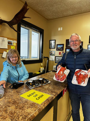
It's been lobster season for a few days now and in Rocky Harbour we buy ready-to-eat lobsters at the fish market for 11 euros each. During a break in the rain, we enjoy the delicious pieces at the picnic table while the laundry dries next door. The meat is really delicious, but it's not much more than a small lunch snack.


A must and the highlight of the park is a boat tour on Western Brook Pond, a former fjord that was cut off from the land after the Ice Age. Up to 600m high rock faces made of granite and slate rise up steeply. In the high season, up to 600 visitors a day pass through here. It is a 3km walk from the parking lot to the boat landing stage. For those with walking difficulties like Karin, there is a golf cart service. On the first day, however, we wait in vain as the tour has to be canceled due to fog. We hope for better weather and stay another night at our beautiful spot by the sea. The next morning, the sun is shining and we set off again for the ferry terminal. Unfortunately, we had neglected to make a reservation and the boat was fully booked with 99 passengers. With places 13-16 on the waiting list, we don't stand a chance and so the boat leaves without us and we make our frustrated way back.


We leave the national park and drive quickly north to Arches Provincial Park. The sea has washed large arches out of the limestone in several places and there are countless different colored stones on the beach that have been polished round by abrasion.
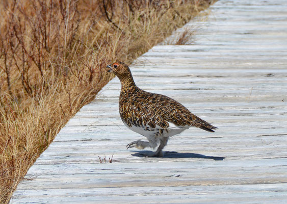
And finally we see some wildlife. We thought it didn't even exist here. Every now and then a moose crosses the road or caribou graze by the roadside. At one point, a moose even visits us at our campsite and is obviously just as surprised as we are.


At Flowers Cove, we learn about the origin of life. Strange rock formations lie directly on the coast. The so-called thrombolites are living fossils and formed the oxygen atmosphere on our planet billions of years ago. These first single-celled organisms only survived in very few places on earth and are responsible for the emergence of life on earth.


We reach St Anthony, the only somewhat larger settlement in the north of Newfoundland, where we can replenish our supplies. From there we head into the wide bays where icebergs can be seen almost everywhere. We fish an ice floe out of the water and later treat ourselves to a drink with Amarula from South Africa and ice cubes from Greenland.


But our destination is the northernmost point with the Viking settlement in L'Anse aux Meadows. A thousand years ago, the Norsemen crossed the Atlantic from Iceland with their families and livestock in open wooden boats and spent at least one winter there. The settlement is located on a large meadow by the sea and in front of it stands a statue of Leif Erikson, the first Viking to land here according to the saga. The site has been developed and the reconstructions of the old sod houses have largely retained their original appearance. From mid-June, the site is a Living Museum and staff dressed as Vikings create an authentic atmosphere. Unfortunately, we can't see this because we are too early at the end of May.


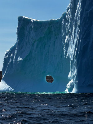
To round off our 5-week tour of Newfoundland, we treat ourselves to a boat trip to the icebergs. With 10 passengers, we head out onto the rough sea in a small nutshell for two hours. But it's worth it. The largest iceberg we encounter is easily the size of an apartment building and being so close to it gives you a completely different impression.


Newfoundland was simply overwhelming for us. Rarely have we been able to enjoy such freedom as we did here. One campsite was more beautiful than the next and the nature was simply gigantic. We gladly accepted the changing weather from sub-zero temperatures and snowfall to summer temperatures of 20 degrees, and the 4000 kilometers we drove.
Now it's 100 kilometers on the Viking Trail back to the ferry to Labrador and from there on along the Labrador Highway to Quebec. As always, you'll find out what we experience in the next blog.
Our route for this part of the journey - 2100 Kilometer

Kommentar schreiben